A must-visit for any casual prospector spending time in the Colorado mountains, Cache Creek was a commercial operation that was shut down in the midst of productive operations. Of all the places open to casual prospecting in Colorado, this is the one to hit if you dream of finding a nugget. No promises of course, it may remain just a dream for you, but it can happen here. The site was privately owned for about 100 years and was repurchased by the Feds (under BLM management) in 1992 specifically to provide a place for gold prospectors to dig…and for the elk winter habitat it represents. Since it is repurchased land, it is unclaimable…open for you to play 🙂
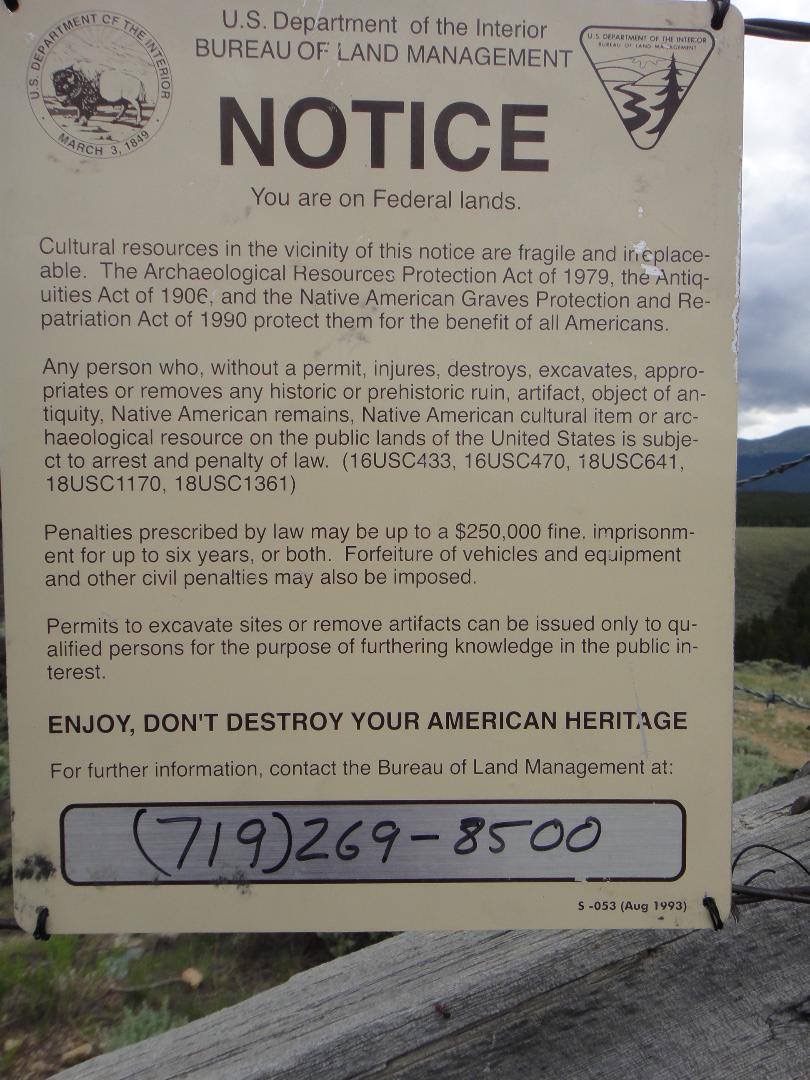
The BLM has discussed formal plans to start charging a small fee to use the site. I suppose this will pay for the port-a-potty setup and such. However, no changes are being made yet. I confirmed this personally with the BLM staff at the Royal Gorge Field Office in Canon City June 5th, 2017. This means no fees, no new restrictions on where we can dig…same rules as recent years. Here’s a pic of the rules posted on site:
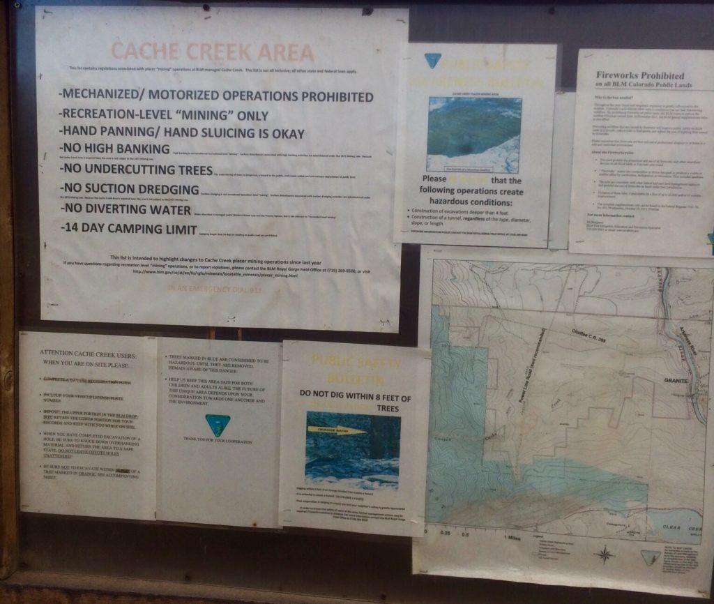
Key points:
- No power or mechanized equipment and no water diversion
- leave your dig site in a safe condition for other users and animals
- no digging near trees
- Dispersed (no drinking water or hookups available) camping is allowed in this area for up to 14 days
- Although you can always walk in, motor vehicle access to the main parking area is limited by a gate. The gate is open from just before Memorial Day weekend through November. (The closure protects winter habitat use by an elk herd – this is where the mommas raise their babies…and reduces road damage.)
To get there follow US-24 to Granite (between Leadville and Buena Vista) and turn west off the highway at Lost Canyon Road. Follow the road up onto the plateau and travel west to the intersection with a road that runs under the electrical wires. Follow that unmarked road southerly (turn left) to an ungraded dirt parking lot. In the lot you will see porta-toilets and the sign with rules and such (I thought about including a pic of the toilets here, but I think you know what they look like!).
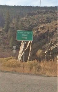
Turn off highway 24 at this sign for Lost Canyon Road. It’s just south of several buildings which are wedged in on the west side of the highway between the hillside and the highway.
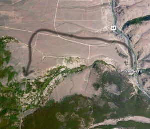
The black line I’ve drawn on the satellite image below shows your route from the Lost Canyon sign to the parking lot via the dirt road under the high-power electric lines.
The reacquired area is quite large here as you can see on the BLM website (2017 update: actually, the BLM took down their website info so look at the map above in the picture with the rules, or my copy below). Onsite, you’ll see piles of material in various states of having been mined. There is gold all over here, in the dirt under your feet as you walk around the artificial valley, in the odd artificial hills left behind by the hydraulic mining and even in the steep hillsides of the valley edge where they stopped hydraulic operations after the court order back over a century ago.
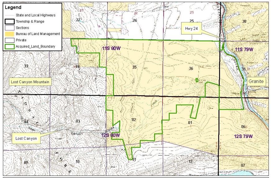
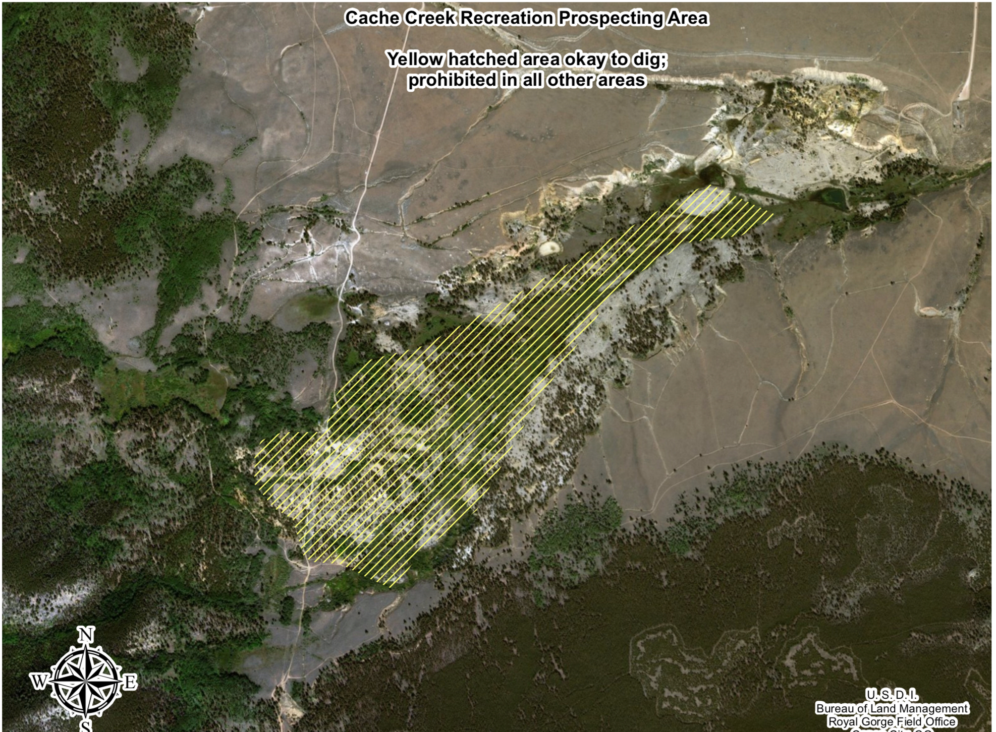
The following map was produced in 2020 to show the area open to active prospecting. It’s essentially the entire mined valley. Areas outside of that are protected for historic reasons. NOTE: the dirt road that runs south through the letter C of “Creek” and then the e of “Yellow” is the powerline road running south to the parking lot. Hopefully this will help orient you for comparison to the other maps in this article.
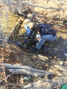
Water flows can vary here by quite a bit, so it helps to have larger and smaller sluices along with you. Generally, the streams flowing through the site are high in the spring during snowmelt and drop as the summer unfolds. Here we see sluices being run in early November with the whole stream of the creek running thru these small sluices!
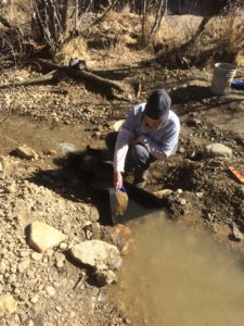
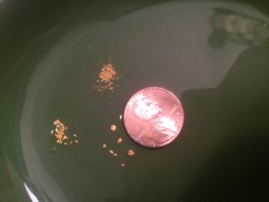
The gold here is mostly quite fine as is typical of Colorado so be sure you are prepared to catch the fine stuff! However, also take a look at the bigger flakes in the picture below. I have found nice larger flakes here even big enough to pick up with my fingers “pickers”.
Gold Prospecting Supplies on AMAZON <= shop on Amazon to support this site!
While you are in the area, you may also want to try digging in the Arkansas River. Here’s info on a public location nearby: https://findinggoldincolorado.com/point-barr-prospecting-site/
History Preservation:
As you drive the dirt road into the site, you’ll drive past a left turn to an old cemetery. Be aware of restrictions applicable to this area. Per Keith Berger of the BLM in 2017: A number of years ago the BLM Royal Gorge Field Office (RGFO), in conjunction with Colorado’s State Historic Preservation Office (SHPO), determined that portions of the Cache Creek acquisition includes the historic Cache Creek placer site. This historical site includes some of the creek and surrounding area, near the Granite Cemetery, and is eligible for inclusion on National Register of Historic Places. Damage to this type of historic property is prohibited by several historic preservation laws (National Historic Preservation Act, Archaeological Resources Protection Act, etc.) and the Code of Federal Regulations, in 43 CFR 8365.1-5 (a)(1).
…so, respect that spot downstream of the active placer area. Don’t dig it.
ACCESS: The gate allowing prospectors to drive all the way to the edge of the main prospecting area is opened the week before Memorial Day each year and closed for winter at the beginning of November. This is to minimize disturbance of the elk on their wintering and calving grounds. You can still walk in year-round of course.
Looking for a chance to stay in a real, restored miner’s cabin near here? These cabins are managed by the USFS and are just a few miles south of Cache Creek on Clear Creek.
Looking for a way to say thanks for all this great info? Send me a small cash gift at Tips for Kevin or consider buying my book! It has more info on this site and 185 other free, public dig sites across the mineralized areas of Colorado. Shop at www.findinggoldincolorado.com/buy-the-book/


29 thoughts on “Cache Creek Prospecting Site”
Thanks for checking on any new rules for 2017!
Enjoyed your site, I have been going to Colorado the last few years and have been to most of the sites you cover. Really enjoyed reading the latest updates. Cliff Cleveland,Texas
Thanks for the praise and encouragement. I’d love for you to comment on some of the other sites where you’ve been. What was it like, how was the gold, any tips or cautions?
Kevin, Really good write up, I am going to give it a try! My name is Kevin also, I’m in Westminster, maybe we will cross paths one of these days.
Hi fellow Kevin! If you go, be sure to walk along the stream looking for a BIG hole created by a dead tree that fell over with its rootball coming right out of the ground. You’ll like the gold there!!
Is the Large parking area north of the day parking area still open
Yes, there have been no changes as far as I know.
Hi Kevin
We ate new to gold prospecting.
We live in the south west Colorado.
Any good places to go pan, and slush?
We are now memoir the gppa. Got the book but only have found mica. Still hunting. I know we will never strike it rich but it’s fun and very educational looking.
I’d suggest you join a local club to get the panning and prospecting training you need. There’s an article on my website here listing all the clubs in the state. I’m sure you can find one to try out 🙂
I am new at this and need a good legal spot to sluce and pan. Can someone give me a detailed map how I can get there.
Well Sonny, there are plenty of free, public access sites documented on my website here. Have you tried any of these?
I’m am grateful that you would share such information.
We are planning our 1st prospecting trip this year.
Any suggestions on where is best?
Thank you for the great information.
There are lots of good places documented here on my website. Try one!
Purchased the book Finding Gold In Colorado and really enjoying reading it. New to prospecting and hope this isn’t a silly question. Are you allowed to use Gold detectors at the Cache Creek area ?
Yes I believe a detector would be fine. No moving parts and heck, they are even allowed in National Wilderness Areas!
We are from central Kansas and have visited the Buena Vista area annualy for many years and just learned of the Cache Creek area. We are extremely new to gold panning so please excuse any incorrect terminology. We are planning a visit to Cache Creek in the near future. We have read the posted rules and regulations but were wondering if a person could take some classified dirt out of the area. We would love to take some back home with us for our grandkids to work with. They would absolutely love it. Thanks in advance for any information you can offer.
I’m unsure what is officially ok to do. I suggest asking the BLM office in Canon City.
That said, I’ve certainly heard of people doing as you suggest.
Are you allowed to use gold Cube up at Cache Creek CO and do you need a permit thanks
No sorry. No mechanical equipment is allowed. Nothing with moving parts, not even a wagon with wheels!
Do you know if we can use a metal detector here?
Well, there’s no rule against it and detectors are allowed in wilderness areas so I think it’s fine. You could always call the Canon City BLM office to confirm.
So can I use a gas powered vacuum in any of the areas that are open to public prospecting? And yes a vacuum not a dredge.
There are areas where gas powered equipment is allowed. However nothing with moving parts of any sort is allowed at Cache Creek.
Do you know the path of the old “9” mile water ditch that brought water from Twin Lakes to Cache Creek?
No sorry, I don’t.
Do you think Cache creek is okay to start digging now or is it still frozen?
Not really. The creek will be flowing now for sure. However, the gate won’t be opened until sometime the week before Memorial Day! As a result, it’s over a mile walk to get to the creek until then. Some of the walk will probably be through snow drifts still.