
Finding the best gold deposits in a stream is a tricky business. It is made more challenging by the fact that there is more than one sort of waterway. When we look at a stream to decide where to do our first sample pans, it helps to know what we are looking at in a little bit of detail. So what are the types of waterways? How do we identify each? Oh, and what do we look for in each one to find the GOLD?
Side Note: if you are new to prospecting, you may want to read this article first which includes some cool videos explaining the basics: https://findinggoldincolorado.com/where-to-look-for-gold/
Also, this one: https://findinggoldincolorado.com/prospecting-101-how-to-read-a-river/
The two broad types of waterways are bedrock controlled and alluvial valleys. Bedrock controlled streams may have gravel bars and a gravel covered bottom BUT their defining characteristic is that the route of the stream is “controlled” or guided and limited by the bedrock. These streams will consistently have either visible bedrock or bedrock under a thin coating of gravels and cobbles. Alluvial Valley streams on the other hand, run through valleys filled with large amounts of sand and gravel with no visible bedrock. Often the bedrock is 20-80 feet below the visible valley floor and riverbed. In these cases, the waterway tends to find its own path rather than being limited by the shape of the bedrock. The difference between these two types of streams is very important to the gold placer prospector. The gold deposits, pay streaks and concentrations are different and so the logical places to test for gold will be different.
First the Bedrock Controlled stream:
In this case the stream will tend to be faster running in a steeper sloping valley. Bedrock streams are usually smaller and the prospector will typically see bedrock outcroppings along the way. This means the water will be very fast flowing, especially when water levels rise. The immediacy of the bedrock forces the water into straight stretches with inconsistent, angular turns. There are a number of examples of this in Clear Creek between Idaho Springs and Golden, Colorado for example. In this topographic map image from Google Maps, we see steep canyon walls forcing the creek to stay in its current path.
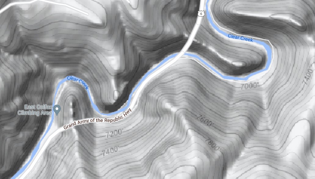
Photo credit: Google Maps
Irregular shapes in the bedrock can make for great gold traps and many prospectors focus on cleaning out those cracks and traps in the rock. The traps can take the form of cracks, pot holes, suction eddies and natural riffles. Since gold will drop out of the water flow in slow spots, reading the stream is particularly important with a bedrock controlled stream. Look for irregularities in stream flow, even when water levels are lower. Of course, if you can observe the stream during a flood state, that is even better since that’s when gold is actually moving.
In areas where the waterway widens, massive floods slack off and large boulders will be deposited. The boulders slow waterflow of course and create small pay streaks. Looking for a line of boulders running one after another can be a good hint to where coarse gold is accumulating.
Because bedrock is always nearby, the advice to find the largest gold “on bedrock” is very relevant here. Dig down or sideways to get to bedrock knowing that those larger flakes and nuggets can’t escape your shovel by working their way deeper! In addition, think about bringing crack cleaning tools to help you get the flakes that have been hiding in the cracks for hundreds of years or more. I have found some strikingly nice flakes that way myself – even in very narrow cracks.
While an eddy can occur in either type of river, it is more common, and longer lasting, where bedrock is involved. An eddy is a spot in the river where the water flows upstream near the bank (or other interruption to normal flow). This upstream flow will circle around and move back into the main downstream-moving flow of the river. An eddy may be big enough to park a boat in, or small enough that stepping into it will interrupt it. Either way, the line along the outside edge of the eddy where water moving downstream is jumbling with water moving upstream will define a pay streak. Since that line will be moved toward the shore (or other interruption to normal flow) when water flow is lower and further out into the main stream during flood stage, it is often wise to sample the riverbed on both sides of this jumbled flow ‘line’. When a stream is forced into a hard turn by bedrock, an eddy will typically form just downstream of the turn. This is a key place to test for gold.
Waterfalls and deep pools on the other hand are not generally places gold accumulates. This is because flood-stage flows scrub out the base of the waterfall. Instead look for the accumulations of gravel on the banks of the pool or just downstream as I mention in my article on these formations here.
Let’s move on to the Alluvial Valley waterway:
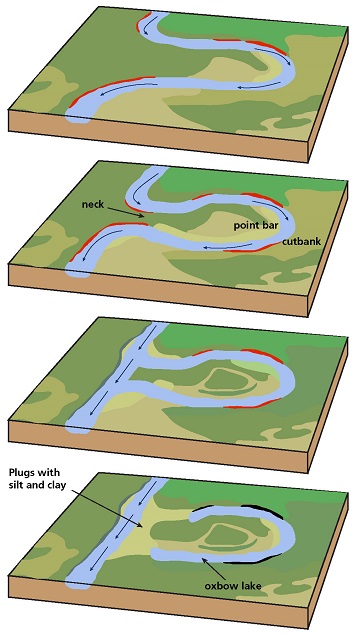
Alluvial valleys tend to be gentler slopes and wider compared to bedrock controlled valleys. This allows a river to form meanders and bends as it snakes its way across the countryside. The more consistent material in an alluvial valley means the river can carve its own path easily. This also means it can create predictable paystreaks along its smoothly rounded curves. Notice the rounded curves in the Arkansas River in this image from Google Maps. The river is flowing across an area of alluvial plain so the river got to form its own curves. As the alluvial banks are eroded, those curves will shift, sometimes slowly over years and sometimes suddenly when there is a flood event. In the image you can also easily see islands, and areas of river with multiple channels, as the river continues to change where it flows on the plain.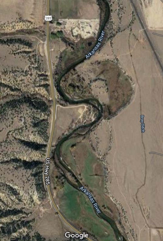
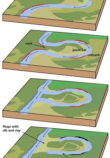
Over the millennia an alluvial stream will tend to move its bed across the alluvial valley floor. This can mean paystreaks get ‘orphaned” by the river as it leaves them behind. Sometimes this means, for example that a paystreak will be exposed in the bank on the outside of a bend in the river (the gold having been left there many hundreds or thousands of years ago when the river followed a different path). However, most generally, the pay streaks will be associated with the inner bank of a bend in the river on a cobble bar which sits exposed during lower water level periods. Depending on how the water behaves when it runs at high flood stage, the gold may accumulate in a variety of areas so quite a bit of sampling may be required to find the best paystreaks on a big inner bend cobble bar. The highpoint of the bar may be rich, however the edge of the bar where it is closest to fast moving water may also be a rich area. Both the head and tail of the bar are worth testing as well. A great example of this in metro Denver is Big Bend (see details here) while Point Barr on the Arkansas is another (details here). The good news about wherever you find the cobble bar paystreak is, it will most likely be larger and more consistent than any paystreak in a bedrock-controlled stream. The bad news is that you’ll mostly just find smaller gold, the larger gold will likely be deeper than you can reach since there is no bedrock to stop it from sinking deeper and deeper into the riverbed! Don’t let the fact that these paystreaks are composed of smaller gold particles discourage you though. When I find a cobble bar or riverbed deposit with some sticky clay or organic matter mixed in, I am often very pleased with the productivity of the paydirt. At one western Colorado spot a friend and I hit, we each produced 1/4 gram per hour with just gold pans…all of it from the top 2-6 inches of material, just below the waterline, at a low flow time. The two of us spent two hours there and came away with a gram of gold between us! To read more about these big cobble bars also called “skim bars”, check out my article here.
Meeting points of two waterways are called confluences. While the area just below a confluence can have a good paystreak in either type of waterway, the paystreaks are more dependable when the waterways are in an alluvial valley and the streams are of similar sizes. Of course a lot of prospectors know about confluence placers so you will have to have a sharp eye to spot good pay-dirt there these days.
Another feature to look for in the waterway is a row of larger cobbles/rocks stretching more or less across the stream. This will indicate a spot where the river is slowing down when it is in flood stage. Just downstream of this row of rocks is a likely paystreak running from one bank to the other…or perhaps only part of the way from one bank to the other. Either way, this is a key area to sample.
In a river with no cobbles, just sand, look for stripes of darker or even black sand in the riverbed. These may be areas where the flow of the river has stripped away the lighter colored, lighter weight quartz sands and left behind the more dense iron sands and other metallic sands…and of course the gold! These deposits will most likely be limited to the top few inches of riverbed. However, if that top layer pays well, it is also wise to sample deeper to potentially identify another, similar pay layer left by the river years earlier.
In an alluvial valley riverbed with lots of cobbles just sitting loose in a single layer on top of a densely solid riverbed, the river flows may have created another concentration of heavy sands and gold. This configuration of cobbles is typically created when a seasonal flood deposits a new layer of cobbles, gravel and sand on the riverbed. The cobbles will drop first being denser, with the gravel and sand settling to the bottom later when the river slows down. The cobbles get re-exposed because of what happens next. Smaller, seasonal storms speed upriver flows enough to strip the new gravel and sand away leaving the cobbles sitting on the older, hard packed riverbed. However, in this process, the heaviest sands (iron sand and gold for the most part) get left behind. They hide under the layer of cobbles and in the first few inches of older riverbed. So, toss aside those cobbles and scoop up the top layer of riverbed to find a natural concentration of paydirt right underfoot. I’ve run into this in many waterways across the state so keep your eyes open for this one. One key place in metro Denver is Arapahoe Bar; read about it here.
One of the surprises of an alluvial valley stream is that the coarse gold can also accumulate in a paystreak running in the lowest point of the river bed. (Side note: the lowest line in the bottom of a riverbed is called the “thalweg”, a word that even my word processor doesn’t recognize!) In a larger river, this may be impossible to access safely, in other cases venturing into the river during its lowest flow periods or with a dredge may be the way to get that bigger gold. Often diving with air will be a necessary part of dredging for this bigger gold deep on the river bottom.
Human Engineering in a waterway:
Either natural type of waterway will be affected by the roads, bridges, flood control structures, erosion control structures and other things humans build around and in the water. Every one of these structures can affect where the gold accumulates and where we are allowed to dig. Structures which interrupt the flow of water will often have small gold streaks just downstream of them…which may extend for a decent way downstream.
When bridge supports are built, a bore hole is typically dug down to bedrock. All of the material which comes out of the bore hole is typically spewed into the waterway in the immediate area. This means just downstream of the bridge support you will often find a gravel bar partially made up of material from DEEP down in the riverbed. This material will often pay quite well even where the gravel bar doesn’t appear to be in a logical spot for gold accumulation. In some cases, bridges are built where bedrock is closer to the surface simply because doing less boring is less expensive. So, if you see a bridge, especially an old bridge, check to see if there is shallow bedrock in this area. Examples of this in metro Denver include the pedestrian bridge over the South Platte River at Grant Frontier Park (see details here) and the 8th Avenue bridge over the river at Frog Hollow Park (details on that dig site are in my Finding Gold in Colorado – Prospector’s Edition book here).
A caution about human engineering: if someone spent money building it, there will be serious penalties if you disturb it. Just don’t. In Colorado, a state Dept. of Transportation regulation bans powered prospecting equipment within 50 feet of their structures (bridges, erosion control structures, etc.) Also be especially careful of the ‘riprap’ – large angular rocks which are placed on a riverbank to prevent erosion. Even digging between those rocks can be judged vandalism.
Conclusion:
Of course a specific river can be bedrock controlled for parts of its distance and flowing through an alluvial valley for other parts. Often the upper part will be bedrock controlled and the lower part will be in an alluvial valley but that is not always the case. At points of transition from bedrock to alluvial valley check for rich deposits as the river widens and slows down. When an alluvial valley river hits a bedrock constraint, interesting riverbed structures will also create good paystreaks. Look for bedrock outcrops, pools and their downstream riffles to find good gold that has migrated down from the alluvial valley and accumulated just downstream of these interruptions to the river flow.
Indeed, a given river can move through both types of landscapes multiple times. The Arkansas River is a good example of this during its first hundred miles or so of flow from above Leadville to Pueblo. There are multiple alluvial valley areas and multiple bedrock controlled areas as it progresses through the high mountains to the plains. This means our gold prospecting strategies have to change as the land around us changes. One last example of this difference: in a bedrock constrained flow, the gold will accumulate just downstream of a bend while in an alluvial valley river gold will often accumulate at the beginning of an inside bend.
Hopefully this article has given you some ideas of what to look for in each type of waterway. Good luck and ”Find Your Gold!”
For more technical references on this topic check out an academic paper by T. E. Lisle, 1986 “Stabilization of a Gravel Channel by Large Stream Obstructions and Bedrock Bends, Jacoby Creek, Northwestern California” Geological Society of America, Bulletin 97, (pp. 999-1011); or the article in ICMJ’s Prospecting and Mining Journal from March 2011 by Jim Halloran “Prospecting with the Help of Fluvial Geomorphology” (pp. 30-38).
Find Your Gold!
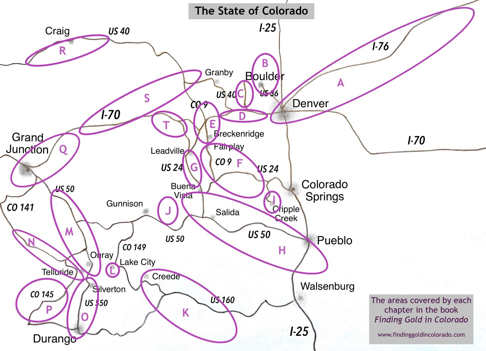
For information on over 180 public access dig sites across Colorado, grab a copy of my book Finding Gold in Colorado – Prospector’s Edition. To help inspire friends and family to plan a trip to beautiful Colorado gold country, get a copy of Finding Gold in Colorado – Inspiring Images. Finally, to keep track of where you have been, the gold you found and what you learned along the way, get a copy of Finding Gold in Colorado – Prospecting Log.
But wait, there’s more!
Want to learn about gold deposits left behind by rivers as they erode downward? Try this article.
Just want a quick way to say thanks? Toss me a couple bucks at Tips for Kevin

14 thoughts on “Gold Prospecting in different types of Streams”