Gold bearing placer streams in Colorado are generally many thousands of years old, sometimes millions of years old. In that much time, a stream can move around and erode much deeper into a valley. As this happens, cobble deposits containing gold can be orphaned, or left behind, by the flowing water. As the stream continues to erode deeper into the valley floor, the old riverbed cobble and gold deposit ends up sitting high and dry on a hillside.
Historically some of these deposits were mined by bringing water across the hillside from a nearby creek to either ground sluice or “hydraulik” (blast the hillside with fire hose-like devices) the deposit. However, in many cases, the deposits were ignored by commercial miners either because they were too small to be worth digging a water ditch to, or because there just wasn’t enough water available uphill.
Today these deposits sit waiting for a prospector using modern equipment. Want some? You bet, right?!
HOW TO FIND THIS GOLD
Identifying a bench deposit starts with finding river cobbles on a hillside as below. One key thing to notice about the larger cobbles is how many of the are positioned in the same orientation. They are sort of flat/horizontal or rising to the right in the photo. This would be typical of a bench deposit made by a river that was flowing left to right (in the photo) when the cobbles were laid down.
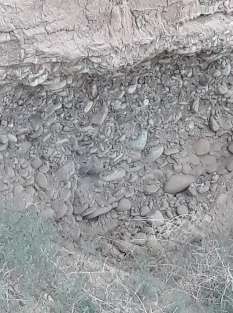
Simple right? Well, not really. Cobbles can also be created by glacial action. Glaciers CAN push gold around with everything else but don’t sort material by density to create concentrations of gold. This means glacial deposits are inconsistent at best and often not worth digging (see exception below). Ok, how do we tell the difference between a bench deposit and a glacial deposit? Generally, the glacial deposit will be unsorted meaning the cobbles and gravel will be mixed randomly while a bench placer will have visible layers of densely packed cobble since it was deposited by a river. Of course, a glacial deposit can also have layers that have been sorted by rivers that flowed in between glacial events or as the glacier melted. In that case, we will see gravels that have been sorted into layers like this:
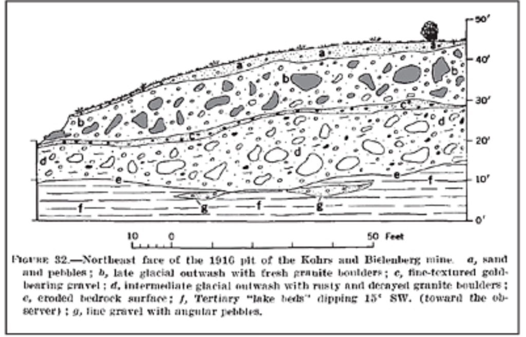
This glacial actions with melt-water streams is what formed the rather unpredictable placer deposits at Cache Creek (see this web article Cache Creek Prospecting Site – Finding Gold in Colorado or site G-03 in my gold prospecting guidebook). The Cache Creek site can vary from sparse fine gold to rich pockets of larger flakes and pickers as diggers get through the various layers, etc.
Here’s a partially mined hillside bench placer in Summit County:
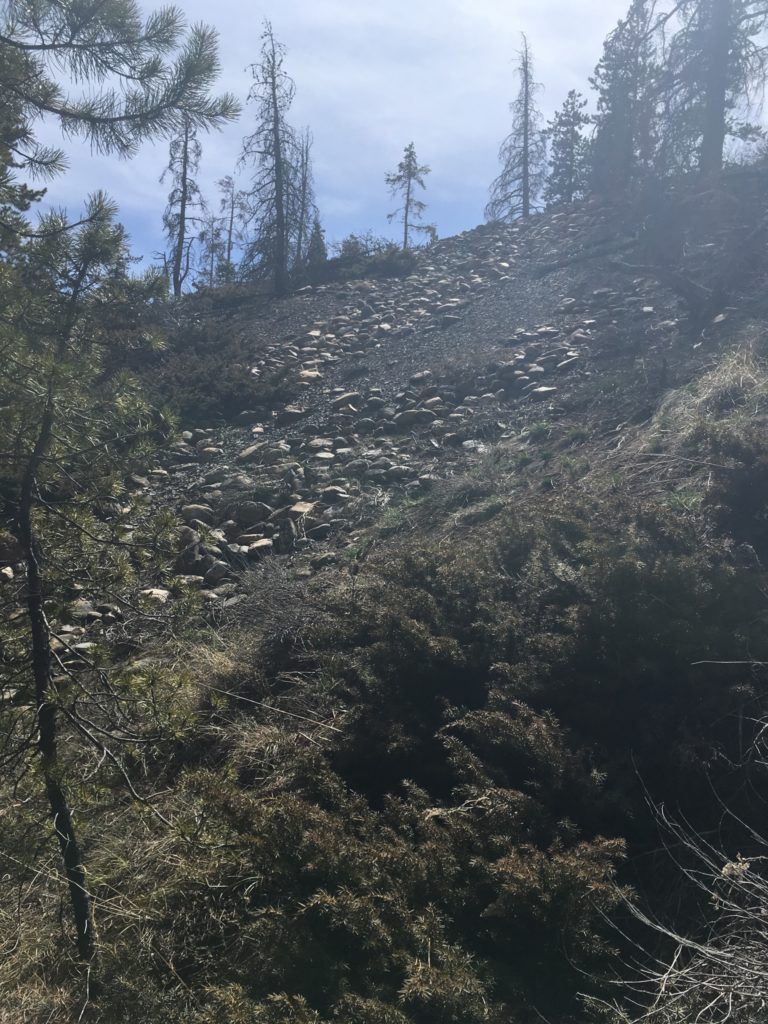
To find a deposit that is unworked, look for rounded river cobbles peeking out of the dirt on a hillside above a modern stream or river. Dig a small sampling trench to see how the cobbles are aligned – are they random (bad news most likely) or laid one on the next in a more orderly way (good news!)? Of course you can run a couple sample pans either way – you never know right? Also keep in mind that there may be multiple stripes of bench placer material deposited across a hillside, or the entire hillside could be one huge bench placer (this is more common on large inside bends).
Another feature that can lead to a specific sort of bench placer is an ancient oxbow:
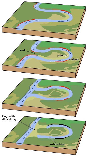
Here we see the sequence of changes in a river that leads to a horseshoe bend which in turn becomes an oxbow lake (bottom picture). The red areas are riverbank that is being eroded away and the yellow is material being deposited. Most prospectors know about the gold potential of at least some of these yellow-marked areas but once the river leaves the oxbow behind, it may continue to cut lower into the riverbed leaving the oxbow high and dry on a hillside. At that point the shape of the ancient river is still there, with a higher hillside/riverbank on the old outside bend and a lower hill on the old inside bend. However the entire oxbow may be dry and overgrown with grasses, bushes, etc. and easy for a prospector to ignore. This can now be called a bench deposit even though the deposit may not be on a hillside reaching directly down to an active waterway – the far point of an oxbow can be hundreds of yards/meters from the nearest river bank. This is still worthy of exploration and sampling. Looking at the images to the left you can see yellow areas all around the inside edges of the old waterway – these are the most likely places to find rich placer deposits. In fact because of the way river meanders grow, the entire island seen in the third image is built from one layer of inside bend deposited after another so ALL of the island is likely to have gold concentrations. This remains true after it is a bench deposit stranded up on a hill. So much to explore!!
HOW TO GET THIS GOLD
Once a deposit has been identified, the modern prospector has several options for processing the materials: If water is available to be pumped up to the deposit, high-banking is the most efficient gold capture method. If not, perhaps the paydirt can be moved easily downhill to the water where it can be sluiced…perhaps via buckets or a hillside slide made from plastic or metal sheeting. Where access to water isn’t an option, a drywasher is the best solution.
Whichever gold recovery method is used, it’s worth remembering that a lot of virgin pay-dirt is out there waiting on hillsides across gold country in Colorado.
For those readers with my book (learn more about the book Finding Gold in Colorado: Prospector’s Edition, or buy it, here), examples of accessible bench placers are at sites C-06, E-03, G-03 and H-01P. M-07 also has bench placers but digging them is forbidden so stay in the water there. The bench placers at M-07 used to be open to casual prospectors but were removed by the BLM due to visiting prospectors leaving big holes on the hillside. This naturally led to erosion concerns and other bureaucratic anxiety. If you dig a bench placer, be sure to push your oversized tailings back in the hole and smooth things over to avoid raising similar concerns.
If you are attracted to a bench deposit in Colorado that isn’t mentioned in my book, be sure to follow the first 3 steps in this link to my article on how to check for claims and private property before digging. If you are clear to dig, you may find some rich virgin gravels since, as I mentioned above, many bench deposits weren’t practical for previous generations of miners to bother with. You may find a deposit with larger or more plentiful gold and decide it is worth claiming now! Here’s my article on how to file your own claim if you decide to go that way.
One other caution: Digging a bench placer can lead the incautious prospector to dig a hole sideways into a hill. This horizontal digging is referred to as a coyote hole. At a larger, professional level, it is call “drift mining”. Put simply, it is very dangerous. I know of two people in Colorado who have been killed when the roofs of their coyote holes fell in on them in recent years. In one case, the person was even working close to others but since it took a few minutes to dig them out, it was too late. Please don’t dig horizontally or enter such old drift diggings without trained, professional guidance.
This site costs money to keep up. The only way it makes money is shopping referrals (or if you buy my book of course). If you appreciate the info I’m sharing, please click thru one of my ads the next time you want to shop online. It won’t cost you anything extra and it keeps the site going: Shop at Amazon
Toss me a gift to say thanks at: paypal.me/buyabook



4 thoughts on “Prospecting bench gold placers”
Hi Kevin Singel,
My husband and I started panning a year ago. I purchased your book last year but we received it after we got back home (Houston). I’ve been reading your book and marking pages that will be helpful to us. I love reading the history you have included. I have a question are you planning to include a map with the locations marked? For example: site D-05 after I read the directions, I opened a Colorado map on my ipad to get a better sense of where the area. My husband and I are coming up next week. We are staying in Breckenridge. Last year, we stayed in Salida. In the past we stayed in Leadville. We will try Cache Creek again. Thank you!
I won’t publish a map with each site marked sorry. The sites are easy to find using google maps, just type in the latitude and longitude like you would a street address and you’ll see exactly where each spot is and how to get there!